ORLANDO, Fla. — Tropical Storm Nicole continues to gain strength as its track aims toward Florida’s east coast. Read live updates below:
>>> STREAM CHANNEL 9 EYEWITNESS NEWS LIVE <<<
>>> DOWNLOAD OUR FREE NEWS & WEATHER APPS <<<
10:00 p.m. update
Tropical Storm Nicole continues to gain strength as its track aims toward Florida’s east coast.
Nicole is now very near hurricane strength with maximum sustained winds near 70 miles per hour and about 325 miles east of West Palm Beach.
READ: Hurricane Safety: What are hurricane categories and what do they mean?
Nicole is strengthening despite dry air making its way into the circulation. Eyewitness News photographer Zack Schwartz was on board the hurricane hunter as they made three passes into the storm Tuesday tonight, with each pass noticing an eye developing.
Tropical Storm #Nicole Advisory 8: Nicole Very Near Hurricane Strength While Headed For the Northwest Bahamas. https://t.co/tW4KeFW0gB
— National Hurricane Center (@NHC_Atlantic) November 9, 2022
Nicole is still forecast to make landfall as a category 1 hurricane on the east Florida coast overnight Wednesday.
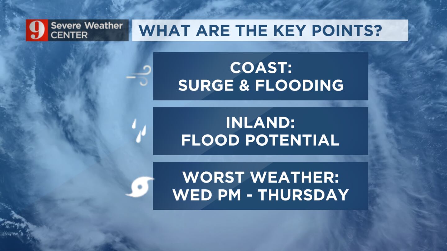
A dangerous storm surge is expected along much of Florida’s east coast and parts of coastal Georgia where storm surge warnings are already in effect.
The National Weather Service is advising residents in the storm’s path toe follow the advice given by local officials.
9:15 p.m. update
Universal’s Volcano Bay theme park will be closed Wednesday due to Tropical Storm Nicole.
Universal Studios Florida, Islands of Adventure and Cirywalk will be open as normal as the resort monitors the storm.
Update from Universal Orlando Resort:
— Universal Orlando Resort (@UniversalORL) November 9, 2022
For more information and FAQs, visit https://t.co/8mwm7e5604 pic.twitter.com/yA4ZM1nDKz
6:30 p.m. update
Walt Disney World Theme Parks are currently operating under normal conditions, but the following Walt Disney World Water Parks and Miniature Golf locations will be temporarily closed on Thursday, Nov. 10:
- Disney’s Typhoon Lagoon water park (Disney’s Blizzard Beach water park is currently closed for the season.)
- Winter Summerland Miniature Golf
- Fantasia Gardens
- Fairways Miniature Golf
6:15 p.m. update:
NASA announced Tuesday that it has decided to re-target the launch for the Artemis I mission to Wednesday, Nov. 16, pending safe conditions for employees to return to work.
As teams continue to monitor Tropical Storm Nicole, we've decided to re-target the launch for the #Artemis I mission to Wednesday, Nov. 16, pending safe conditions for employees to return to work. https://t.co/08yHOd2a17 pic.twitter.com/QfWhjyTlE7
— NASA (@NASA) November 8, 2022
5:05 p.m. update:
The city of Orlando will waive parking fees for the following parking garages beginning at noon on Wednesday, Nov. 9 for any resident who would like to park a car in a covered garage.
- Central Boulevard Garage, 53 West Central Boulevard
- Jefferson Street Garage, 62 West Jefferson Street
- Library Garage, 112 East Central Boulevard
- Orange County Administration Garage, 300 Liberty Avenue
This is for passenger vehicles only and height restrictions must be adhered to. No oversized vehicles, campers, boats, trailers, watercraft, etc. will be permitted to enter. All cars should be removed by noon Friday, Nov. 11.
4:40 p.m. update:
Orange County Public Schools will have regular early dismissal on Wednesday. The district said there will be no school Thursday and Friday. There will also be no extracurriculars or extended day programs Wednesday through Friday.
TS NICOLE UPDATE: Regular early dismissal Weds 11/9. No school Thurs and Fri 11/10 or 11/11. No extracurriculars or Extended Day W - F. Info to come on football playoffs and makeup days. pic.twitter.com/J5gIMSHMrC
— ocpsnews (@OCPSnews) November 8, 2022
4 p.m. update:
As of the 4 p.m. update, Tropical Storm Nicole strengthened slightly and is forecast to become a hurricane tomorrow before making landfall on Florida’s east coast Wednesday overnight into Thursday morning.
Winds are up to 65 mph, which is a slight increase. The storm is less than 400 miles off Florida’s east coast, approaching at 10 mph. Nicole is slowly becoming more organized.
4PM UPDATE...Nicole a little stronger and expected to become a hurricane by tomorrow ahead of Florida landfall. pic.twitter.com/djemIl5D2U
— George Waldenberger (@GWaldenWFTV) November 8, 2022
3:55 p.m. update:
Orange, Brevard, Flagler and Volusia counties will all open storm shelters on Wednesday. See a list of available shelters here.
Read: Tropical Storm Nicole: Here’s where shelters are opening in Central Florida
3:20 p.m. update:
Melbourne Orlando International Airport officials announced that the airport will close at 2 p.m. on Wednesday due to Tropical Storm Nicole.
MLB will close at 2pm on Wednesday, November 9 due to Tropical Storm #Nicole. For flight info and updates, please contact your airline. As a reminder, the airport is not a designated shelter location. Stay tuned for updates and stay safe! pic.twitter.com/65zFuTU7GE
— Melbourne Orlando International Airport (MLB) (@FlyMLB) November 8, 2022
Orlando International Airport announced that the airport would cease all commercial operations at 4 p.m. Wednesday.
Officials at both airports tell passengers to contact their individual airlines and rental car companies for specific questions about flights, schedules, and rental car return policies.
3:00 p.m. update:
At a briefing, Tuesday Flagler county officials urged residents and businesses to prepare for tropical storm-like impacts.
No evacuations have been ordered but residents along the barrier island - from the Volusia County line to the St. John’s County line - should be prepared to evacuate as early as Wednesday morning if necessary.
Rymfire Elementary School has been designated as a shelter should residents need to evacuate and will open Wednesday at 3:30 p.m.
Flagler Schools Superintendent Cathy Mittelstadt said schools will have an early release Wednesday, Nov 9.
Mittelstadt said middle school students will be released at 12 p.m., high school students will be released at 1 p.m., and elementary school students will be released at 2 p.m.
Classes and all campus or district activities for Nov 10 are canceled. Flagler schools were already closed Friday in observance of Veterans Day.
2:50 p.m. update:
Kennedy Space Center Visitor Complex will be closed Thursday, Nov. 10, due to expected severe weather from Tropical Storm Nicole.
The visitor complex will remain open on Wednesday, Nov. 9, but all Kennedy Space Center Bus Tours and Kennedy Space Center Explore Tours will be closed. This includes access to Apollo/Saturn V Center. The main visitor complex will remain open for normal operations.
During Thursday’s closure, guests will not be permitted onto visitor complex grounds.
2:30 p.m. update:
Volusia County
A mandatory evacuation order has been issued for coastal areas in Volusia County.
Officials said they want people who live in areas east of the Intracoastal Waterway and Interstate 95 as well as low-lying areas and mobile home and RV parks to evacuate by 4 p.m. Wednesday.
Brevard County
Brevard County has recommended that the following groups evacuate, starting at 7 a.m. Wednesday:
• Residents who live on barrier islands, including Kennedy Space Center to the south beaches and Merritt Island
• People living in mobile homes or manufactured housing
• Those in low-lying, flood-prone areas
• Those with special medical needs, such as electrical dependence
Evacuating residents are encouraged to stay with friends or family, at a hotel or a public shelter.
Shelter details will be announced Tuesday afternoon. Officials will give a live update at 3 p.m. Stream it live here once it begins.
Evacuation recommended for the following:
— Brevard EOC (@BrevardEOC) November 8, 2022
🧍Residents who live on barrier islands, including KSC to south beaches, & Merritt Island
🧍Mobile homes/manufactured housing
🧍Those in low-lying, flood-prone areas
🧍Those with special medical needs such as electrical dependence
1:40 p.m. update:
Volusia County Schools said it will be closed Wednesday and Thursday due to Tropical Storm Nicole.
The University of Central Florida said it will also suspend campus operations and all classes, including online classes, Wednesday and Thursday. UCF is already scheduled to be closed Friday in recognition of Veterans Day.
Marion County Public Schools is cancelling school Thursday and all extra-curricular activities starting Wednesday afternoon, with the exception of Marion Afterschool Programs. See a full list of school closures here.
Read: Tropical Storm Nicole: School closures in Central Florida
Due to the storm, the Florida Department of Transportation said it will suspend SunRail service, beginning Wednesday.
The Orlando Sanford International Airport said it will close at 4 p.m. Wednesday.
And Brevard Zoo said that in an abundance of caution, it will be closed Wednesday and Thursday, with plans to reopen Friday pending any possible damage.
Latest models on Nicole. More models coming into agreement with direct hurricane impacts to Brevard County. Note: You want to be on the south side of landfall, as areas north of the center will see the strongest winds and more prolonged onshore winds leading to higher storm surge pic.twitter.com/40lbcbujN2
— Rusty McCranie (@RMcCranieWFTV) November 8, 2022
Here are the latest impacts we expect from Nicole, county by county. pic.twitter.com/HcJYvEivdf
— Rusty McCranie (@RMcCranieWFTV) November 8, 2022
Any area of the coast that is north of the landfall of Nicole will get the brunt of the storm surge and water inundation due to onshore winds. Storm Surge will be 3-5' and higher. Surf height forecast is 10-15' breakers near the shoreline (maybe up to 20'). 2 story tall waves. pic.twitter.com/vLYFz1wNnk
— Rusty McCranie (@RMcCranieWFTV) November 8, 2022
Hurricane Warnings for Brevard and coastal Volusia and coastal waters. Tropical Storm Warnings for Orange, Seminole, Osceola, Lake, and inland Volusia. Tropical Storm Watch everywhere else. A Hurricane Warning means hurricane conditions are likely (winds 74mph+) in that area. pic.twitter.com/xH7qTEwGMa
— Rusty McCranie (@RMcCranieWFTV) November 8, 2022
11:15 a.m. update:
Certified meteorologist Rusty McCranie said Channel 9′s in-house computer model continues to show a farther north track for Tropical Storm Nicole, with landfall near the Volusia-Brevard county line.
He said other models are close to matching this track.
Read: Hurricane supply checklist: What should you include in your kit?
“(We) have to watch if this is a trend,” he said.
All public schools in Brevard County will be closed Wednesday and Thursday because of the storm and Friday due to Veterans Days.
Read: Tropical Storm Nicole: School closures in Central Florida
All Osceola County public schools will be dismissed an hour early Wednesday and closed Thursday. See a full list of school closures here.
Watch Channel 9 Eyewitness News at Noon for live updates, and download our free news and weather apps here to stay informed in between newscasts.
Our in-house IBM GRAF model continues to show a farther north track of Nicole. With landfall near the Volusia/Brevard line. This model has been farther north the past 24 hours, and more models are coming now close to this track. Have to watch if this is a trend. pic.twitter.com/IkDMj1HYRm
— Rusty McCranie (@RMcCranieWFTV) November 8, 2022
10:15 a.m. update:
Nicole has gained full tropical storm status as winds consolidate around the center of circulation and the system’s pressure falls.
The National Hurricane Center’s 10 a.m. update indicated a northward shift in the storm’s track, which now brings in more of Central Florida’s coast into play in terms of landfall.
Tropical Storm Nicole could still reach hurricane strength.
All Osceola County public schools will be dismissed an hour early Wednesday and closed Thursday.
10am Tuesday: Nicole has gained full tropical status as winds consolidate around the center of circulation and pressure falls. Note the shift north in the track, now bringing more of our coast into play for landfall. Nicole could still reach hurricane strength. pic.twitter.com/0YhFa4VpNT
— Rusty McCranie (@RMcCranieWFTV) November 8, 2022
9:30 a.m. update:
Osceola County is providing sandbag distribution at Osceola Heritage Park.
Osceola County residents may fill and make sandbags until 6 p.m.
<<< See a full list of sandbag sites in Central Florida >>>
8:45 a.m. update:
State leaders are reminding residents to fill their prescriptions before Nicole impacts the state.
Storm damage and power outages may prevent people from refilling prescriptions after the storm hits.
🌀 Due to potential impacts from #Nicole, 34 counties are under a State of Emergency.
— FL Division of Emergency Management (@FLSERT) November 8, 2022
💊 Storm damages & power outages may prevent you from refilling prescriptions after a storm. Take the time now to refill prescription medications.
➡️ Read the EO: https://t.co/s7I6HHyxIG pic.twitter.com/3sdy4vhLj3
There are 34 counties in Florida that are under a state of emergency due to potential issues from Nicole.
8 a.m. update:
Officials in Central Florida are reminding residents that flooding can happen anywhere, not just in FEMA-classified “flood hazard areas”.
Original report:
The National Hurricane Center said Nicole is forecast to become a tropical storm Tuesday evening.
Watch: ‘Condo buildings in peril’: coastal city asks county for evacuation order
Channel 9 meteorologist Brian Shields said it’s possible that Nicole could be a Category 1 storm as it makes landfall in Brevard County, or just to the south, sometime Wednesday evening into Thursday morning.
*** SHIFT NORTH: Higher Impacts Possible ***
— Brian Shields, WFTV (@BrianWFTV) November 8, 2022
There is a higher likelihood that Nicole moves right into our coast tomorrow night (Wednesday Night) as a hurricane...
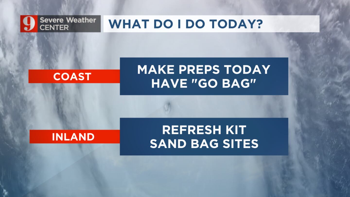
TODAY ~
COAST: Make full preps. Shutters up. Have a "go bag" in case you need to evacuate... (1/...) pic.twitter.com/hZnjg6MQOR
Shields said now is the time to make full hurricane preparations on Florida’s east coast.
The NHC said a dangerous storm surge is expected along much of the east coast of Florida.
Watch: Lake County residents still reeling from Ian floodwaters brace for Nicole
Nicole is expected to cause coastal damage and some inland flooding.
Tuesday will be windy and there will be some fast-moving showers in Central Florida.
Follow our Severe Weather team on Twitter for live updates:
Visit our hurricane section: EYE ON THE TROPICS
Click here to download the free WFTV news and weather apps, click here to download the WFTV Now app for your smart TV and click here to stream Channel 9 Eyewitness News live.

©2022 Cox Media Group